6-14 May 2006 Expedition to Sabah's Lost World


6-14 May 2006 Expedition to Sabah's Lost World by the Malaysian Nature Society (MNS), Pathfinders Special Interest Group
"The isolated and mysterious Maliau Basin, also known as Sabah's Lost World, has only recently been investigated by researchers. Two major expeditions in 1988 and 1996 have discovered a diverse and distinct flora." - quote from Visitor's Brochure printed by the Conservation & Environment Dept., Forestry Division of Yayasan Sabah.
I have heard of the Lost World from fellow MNS members during my Imbak Canyon expedition in Nov. 2005. Therefore, I did not hesitate to sign up as soon as the announcement was made by the MNS that a trip would be organised in May 2006. The explorer in me was curious to compare the level of difficulty of traversing the trails of two adjacent yet distinct biospheres in the heart of Sabah, and to savour the sights, sounds & scents of a different world far from civilization.
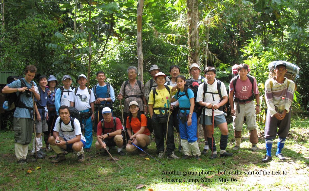
In April & May the preparations began in earnest. We had several briefings by the organisers, the Pathfinders, whose leaders (Wye Ping, Mok, Fei Chin, Sidney) ably demonstrated their vast experience and competence to prepare a motley team of 14 participants (10 men & 4 ladies, their age from twenties to sixty) for the rigours of a 9-day trek in deep and undulating jungles. Wye Ping & Mok were to accompany us for the 9-day expedition.
Fri. 5 May 06
Mok , Liau and I were to fly to Tawau a day earlier than the main team. Being "senior citizens" we had the advantage of getting discounted fares from Malaysian Airlines. I took the KTM commuter train at the Kepong Station and arrived at the KL Sentral station at 10am. Then I hopped on the KLIA Transit train and it reached KLIA half an hour later. I was the first to arrive and waited for Mok and Liau to turn up. Together we checked in as a group to save on the amount of payment from excess weight because of the boxes of packed food that were needed for the trip. MAS allows 20kg. of check-in luggage, AirAsia limits the weight to only 15kg. However, Mok still had to pay about RM300 for the food boxes.
The MAS flight was delayed for about 20mins. and we arrived at Tawau at 3.45pm. I had a nap while Mok & Liau went to tour the area around the Grace Inn where we were putting up for the night. Tawau had been visited by me in Feb. 04, on my way to Sipadan Island for a diving excursion, so I was not particularly keen to join them.
At that time I did not inform them that my left knee was aching, the strain from the 29-30 April 06 Gopeng-Cameron Highland trek apparently had not sufficiently recovered. As the expedition went underway I was becoming more anxious by the day, praying that my left knee would not incapacitate me.
Sat. 6 May 06
We met the rest of the team when they arrived in the morning on an AirAsia flight. We went to the UMNO building where the Yayasan Sabah Forestry Division office was housed to register and obtain our entry permits. After lunch, at 1.15pm. we left Tawau in four 4WD Landcruisers for the 190km. journey and travelled on the newly constructed Sapalut-Kalabakan road, stopping at Kalabakan (a small logging village) at 3.30pm for refreshments. From Kalabakan onwards, the gravel road turned into a mud track riddled with deep pits, giving us a bone rattling ride. We passed by many huge timber lorries fully laden with logs as we headed towards the Maliau Basin Security Gate. Here at the Security Gate we had to show our entry permits.
Our leading Landcruiser snapped its compressor belt, rendering the air-conditioner kaput. Further on, the radiator began to overheat. Encik Tahir, a veteran of a decade of timber-truck driving, applied quick "traditional medicine" - poured into the radiator curry powder. Hey presto! It worked - the curry got cooked and blocked the leaks in the radiator. Don't you know that hot curry makes good coolant? However, it was far from cool inside and we wound down the windows, some panes came down half-way and others not at all. The twelve-year old jalopy seemed to be coming apart.
Then it was the last stretch of 26km. hard ride to Agathis Camp. There were several anxious moments when one or the other of the 4WD vehicles struggled to free their wheels from the grip of mud-pits. As we were approaching the camp, it was already dark. The head-lights of the leading vehicle (in which I was seated) dazzled several bearded pigs (Sus scorfa) and red barking deers (kijang/Muntiacus muntiak) who were on the logging road and they scattered terrified back into the dense shrubs.
Finally, to our great relief, the four Landcruisers made it up the hill to Agathis Camp. It was after 7pm. and a dark night at Agathis Camp because the generator failed to work. We cooked by candle-light and torches and was resigned to having our first dinner here in gloom when the lights finally came on at about 9pm.
After dinner, Koh Ju Ming, a Sino-Kadazan, who was the chief ranger at Agathis Camp, gave us a briefing on conditions of the trails, distances & times expected to reach the various camps and general safety measures. Three other rangers were introduced to us and they would be our guides throughout the expedition.
Agathis (referring to the majestic tree of that name), being the base camp, has the best amenities - pipe water (sourced from the waterfall nearby), electricity (from diesel-powered generators), a large kitchen, clean bathrooms and even flush-toilets. Beds were hammocks strung across wooden frames, they were quite comfortable to lie on, and we were even provided with pillows and blankets. By jungle standards, this was 4-star accommodation.
Sun. 7 May 06
After having breakfast and packed our lunches, It was time to get our backpacks and food packages weighed for the porters who charged us RM300 per 12kg. for the 6-day duration until our return on Thur. 11th. I had packed my belongings in a separate duffel bag and and together with Liau's backpack (we were sharing porterage) the weight came up to 11kg. and we topped it up with one kg. bag of rice. My daypack weighed 8.5 kg. and it contained stuff which I would need along the trails (camera, GPS device, compass, lunch in mess-tin, snacks, 2L of water, wind-breaker, hat, poncho, torch-lights, whistle, pocket-knife, first-aid kit, anti-insect & anti-leech repellent & medication).
It was only after 10am that we were ready to leave for Ginseng Camp, a 9km trek on a north-easterly direction. Soon we were made aware of the numerous leeches infesting the trails. I encountered for the first time the species of Tiger leech, a large specimen which when fully stretched measured up to 5cm. and had a striking yellow & black stripe running the length of its body. It was voracious and tenacious. Once it had sunk its teeth on your skin, you would not be able to pull it away even if you dismembered its head from its body. The proper way to remove it was to apply a pinch of salt or a dab of minyak kapak (mixture of methyl salicyclate, methol & camphor), tiger balm, Mosiguard or sterilizing alcohol to the leech and it would release its teeth and crawl away. The bite would continue to bleed for about half an hour (longer if the dismembered head was left attached because anticoagulant from the leech's mouth would continue to ooze into the wound), leaving a bloody patch on your skin and clothing. Worse still, the wound would itch for a week (greater possibility of infection if the leech head was still attached).
At 1pm. we stopped for lunch. During the half hour of rest, we helped each other to remove leeches from our socks and backpacks, and to apply more anti-leech repellent on ourselves. This became the routine whenever we stopped to rest.
Continuing on our trek, we reached Ginseng Camp (altitude about 700m/2300ft) at 3.20pm, so it took us only 5hrs. 20mins. for the 9km. Agathis-Ginseng trail, a very commendable time indicating a high level of fitness. Ginseng camp, named after one small Ginseng plant, would be graded 3-star for its comfortable lodging and living amenities. There was electricity, piped water and flushed toilets, hammock beds were similar to the ones at Agathis, the kitchen was spacious though cooking had to be done by firewood. We were kept busy washing our clothes and helping to prepare for dinner. Dinner was an enjoyable affair, the food was delicious and ample for our huge appetite, and there was much laughter and fun. The advice by Wye Ping to talk quietly and respect the jungle's tranquility went with the wind, there was a cacophony of human jabber, horn-bills' calls and cicadas' serenades.
Mon 8 May 06
Today was supposed to be an easy trek to Lobah Camp, only 3km. away. Refreshed after a good night's rest we made our way at 8.40am. We were still moving in a north- easterly direction, getting deeper into the Maliau Basin, and the trails were getting narrower as we passed by huge Agathis trees and Shorea (seraya) trees with giant buttress roots. We were walking on a red carpet of decomposed leaves, the ground was peaty and slushy. Strange scents wafted through the air.
Our leisurely trek took us just over 2 hours to reach Lobah Camp (altitude 873m./ 2864ft.) at 10.50am. While we ate our packed lunch the rangers were kept busy stringing our hammocks. Lobah Camp had the barest amenities, two wooden huts with plastic sheets as walls, zinc roofs and, surprisingly, a squatting toilet which could be flushed. However, water that was collected from the roof gutters was only sufficient for cooking and drinking, not enough for bathing. After lunch, we walked up a hill to the helicopter pad where we enjoyed a breathtaking panoramic view of the Maliau Basin rim. It would be like standing in the centre of Singapore, and turning around, the eyes could see beyond the shores because the circular perimeter of the Maliau Basin is bigger than the island of Singapore.
Then it was time to trek to the Maliau Falls (altitude 990m./3250ft), another 2.5km away from Lobah Camp. At 12.20pm we set forth, the trail gradually ascending, then a steep drop of about 200m. and at 2.40pm. we sighted the magnificent 7-tiered Maliau Falls, the tallest being 35m. high. From our location, we could only see the 5th & 6th tiers. The immense volumes of water billowed down and mists of spray hit us even at a distance of 200m. The churning waters and rapids were not conducive for swimming, so we were contented to bathe ourselves along the banks, keeping well away from the swift current.
We could not stay long as we had a 2-hour return trip and the fittest members reached camp at about 5pm. I got ready to photograph the sunset, and proceeded up the hill. The sunset was not so spectacular because of the presence of large cumulo-nimbus clouds and the sun seting behind a clump of tall trees on the western slope of the hill.
Tue 9 May 06
I woke up at 5am. and trudged up the hill again, this time to watch & photograph the sunrise. It was much better than the sunset, and my determination was rewarded with a stunning view as the sunlight bathed the rims of the basin with golden rays.
It was a late start today, at 8.40am, before we headed for Camel Trophy camp, a long 9km-trek ahead of us. We were gradually ascending above 1000m., at this altitude the trail became mossy and we passed through heath forest where rhododendrons, orchids and pitcher plants thrived. We proceeded cautiously and faced a challenging task of ascending Bukit Microphone (altitude 1035m./33395ft.) As I reached the summit, I slipped and fell. Fortunately, I was not injured though the fall resulted in a bent trekking pole which could no longer be retracted completely. Better a bent pole than a broken leg.
At the top of the hill was a tall Rengas tree with peeling reddish bark and we were warned not to touch the black sap on the bark. This resin is poisonous and causes severe skin inflammation.
Keeping a safe distance from the Rengas tree, we had lunch which I found to be most unappetizing, the third time we had the same monotonous fried rice, with barely visible pieces of anchovies and scrambled eggs.
We made it to Camel Trophy camp (altitude 1017m./3337ft.) at 2.50pm, a trek of 6hr. 10min. Camel Trophy camp is a double-storey wooden bungalow with the sleeping quarters on the upper floor. The kitchen was small with 2 firewood stoves. In contrast, the dining hall was spacious and airy. The bathrooms and toilets were clean and there was piped water, collected from the rain-gutters. This time we slept on mattresses, instead of hammocks, and we were even provided with pillows. However, the floor was dusty, but we were too tired to care much. By jungle standards, Camel Trophy would rate two and a half star. I subtracted half a star because the smoke from the kitchen could be acridly smelt on the floor above. I had an unpleasant acute episode of irritated eyes, running nose and a dry throat (symptoms of rhinitis). Unlike Ginseng & Lobah camps where I could keep a distance from the kitchen, I had to endure two whole nights of a lingering smell of burnt firewood while I tried to sleep.
At the back of the camp, a 30m/100ft vertical aluminium ladder would take you up to an observation platform at the top of a tall Agathis tree. I climbed about 20 steps, my left knee gave a sharp pain and I felt fatigued. So curiousity gave way to prudence and I descended.
After dinner we were treated to a rare sighting when a civet, bigger than a large cat, came to partake of the lure of food which the rangers had placed next to the dining hall. Evidently, this civet was fed whenever there were visitors at the camp, so as it eyed us warily it nibbled at the food, and we admired its beautiful black & white fur.
Wed 10 May 06
We started the day by trekking to the Takob Akob waterfalls (altitude 1067m. /3500ft.) This trail took 2 hours, passing huge rock boulders and down slippery slopes, at times the descent was nearly vertical, the difficulty somewhat reduced by the placement of aluminium ladders at the steepest gradients. Takob Akob had a 100m. drop of plunging deluge and a pool the size of 2-football fields. In this idyllic setting we had our lunch.
There were three of us who braved the cold to swim in the pool. As I reached the cascading end of the pool, I began to shiver and realized that it was a foolhardy act, and immediately turned around. Fighting a rising sense of fear, and suppressing my rapid breathing, I swam the longest 100m. of my life. I quickly dried myself, put on dry clothes and my windbreaker to counteract the hypothermia. It was a full five minutes before I could steady my frayed nerves. This was an awakening experience not to overestimate my ability. Even though I thought I was a good swimmer (regularly lapping 800m. in under 30min. ), I could not withstand cold and my body lost heat rapidly.
Feeling pensive, I packed my things to leave, among the last to do so, and it started to drizzle. The quick walk made me perspire and brought some relief. At 2.10pm I met up with the rest at a junction which led back to the camp or the Giluk Falls. Feeling much calmer, I ventured with 3 others and the ranger Koh to proceed to Giluk Falls whereas the majority decided to return to camp. It took only 20min. to reach our destination, and I was glad I came along because Giluk Falls was a most scenic spot and the drizzle had stopped. I was able to capture many excellent shots of the falls.
That evening I had to face more smoke from the kitchen and my rhinitis worsened so I decided to sleep early and not wait for the civet to show up (it did showed up with its offspring). I had enough excitement for the day.
Thur 11 May 06
After 4 days of walking more than 30km. of difficult terrain most of us were beginning to feel our energy slowly draining. So we had to psych ourselves up for the last 7.5km. stretch. We were briefed the previous night that the final 2.6km of the return trip would be a steep descent. I dread this stretch the most because of my bad knee. At 9.05am we headed back to our base at Agathis Camp. The first 5km. was a gentle descend which progressively gave way to many vertical 100m. to 150m. drops, thankfully we clambered down ladders or, where there were none, slithered down as cautiously as we could. Where the trail was especially muddy, as we were descending several of us slipped and fell, bumping our butts.
We came to the part of the Heath forest known as "Jalan Babi". It was like walking through an enchanted garden, on a carpet of soft, glistening moss with numerous orchids (yellow and red dendrobiums) and different species of nepenthes, from 1-inch "dwarf" to 8-inch "giant" pitcher plants alongside the trail.
At 1.10pm we reached base camp, so it took us slightly over 4hrs. We quickly settled in and used most of the day to clean ourselves and wash our thoroughly soiled clothings. At the hearty dinner there was much rejoicing, tingled with expressions of relief, that we had made it through a 41km. trek unscathed.
The day ended with a two-hour ride along the logging trail to spot nocturnal animals. I chose not to go because of my bad knee which by now was aching even as I sat.
Fri 12 May 06
After a late breakfast we left at 9.45am for Belian Camp, a 30km ride away, which was famous for its 300m Canopy Walkway. At about 11am we arrived, leisurely strolled around the camp which had a spacious kitchen, dining area and clean toilets/ bathrooms. Camping is allowed on the grounds, with the sites neatly laid out in rows for campers to pitch their tents. There is no dormitory. From Belian Camp there is a trail to Maliau Falls, requiring three days to make a return trip.
The main attraction is the Canopy Walk. We gamely sauntered up the suspension bridge, the higher we went the further we could look over the tree tops. What a feeling of swaying over a hundred feet high, and surveying a canopy of luxuriant foliage. Gleefully, I rested on the platforms and let the green serenity of the forest and refreshing breeze apply a soothing balm on my strained sinews.
Reluctantly making my way down, I joined the rest for a short trek to the lower reaches of the Maliau River. The water was reddish brown and acidic from the constant percolation which leached tannin from the peaty decaying leaves and created the tea-coloured stain in it.
The sky turned dark and poured down a heavy shower for an hour so we could only head back to Agathis at 2pm. The rain made the return trip uncomfortable, the 4WD jeeps had to zigzag sharply lest the wheels got bogged down by the mud. Only two vehicles in front made it up the hill to Agathis Camp, the craters they made deterred the remaining two from going further. So there were eight of us, feet squelching deep in sludge, and I took the opportunity to snap a couple of shots of us trudging up the hill.
Sat 13 May 06
All adventures come to a grand meal, that thought was uppermost in our minds as we left Agathis Camp on a sunny morning. It was an uneventful return trip to Tawau. The highlight of the day was at the Good View Seafood Restaurant where we had a 7-course dinner fit for 16 hungry adventurers. It was a sumptuous, delicous dinner, spiced with mirth and merriment.
Sun 14 May06
Our friends left for Kuala Lumpur in different groups as they were booked on different flights. We had said our goodbyes the last evening so we did not see off those who left the earliest. I was the last but one group to leave so there was plenty of time to roam the streets of Tawau. The best attraction in Tawau was its sea-food and at the market I had good bargains for dried scallops, anchovies and prawns. The MAS plane touched down at KLIA at 9.30pm and I finally reached home at about 11.30pm.
My comparison of the level of difficulty was that the trails at the Maliau Basin were more difficult than the ones I had experienced on the Imbak Canyon expedition. Each terrain had its own unique magnificent waterfalls, highly diversified flora and fauna. These pristine wonders are worthy of repeat visits.
Fore more photos of the expedition see:
http://asia.pg.photos.yahoo.com/ph/yeohcweng/album?.dir=9bdescd&.src=ph&store=&prodid=&.done=http%3a//asia.pg.photos.yahoo.com/ph/yeohcweng/my_photos
----------------------------------------------------------------------------------------------------------------------------------------------------------------
Information on the Maliau Basin
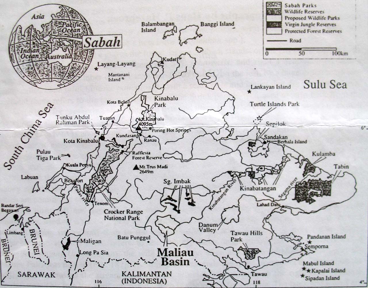
Location: South-central Sabah, approx. 40km. north of the Kalimantan border
Size: 58,840 hectares/588.4 sq. km. Max. diameter of Basin: 25km.
Extent: The whole of Maliau Basin (39,000 hectares) plus an additional 19,840 hectares of land to the east and north of the rim including the 20-hectare Lake Linumunsut (Sabah's only true lake).
Elevation:
Approx. 300m. a.s.l., up to a steep escarpment enclosing most of the sub-circular basin, peaking on the northeastern rim at 1,676m. a.s.l. Gunung Lotung is 1,600m. a.s.l.
Status:
Originally part of Yayasan Sabah Concession area and voluntarily designated as a Conservation Area in 1981 for research, education and training purposes. Upgraded in 1997 to a Class 1 Protection Forest Reserve and extended to present size. Gazetted as a Cultural Heritage Site under the state Cultural Heritage (Conservation) Enactment in 1999. Day to day management by Yayasan Sabah on behalf of Maliau Basin Management Committee.
Rivers:
Draining the whole Maliau Basin is the Maliau River and its tributaries. The famous 7-tiered Maliau Falls is located along this river, which flows out through a narrow gorge on the south-east side of the Basin into the Kuamut River, a major tributary of the Kinabatangan. Several other spectacular waterfalls (Takob-Akob, Giluk, Mempersona waterfalls, 16 known so far) are located throughout the Basin.
Outside the northern rim of the Basin lies Lake Linumunsut, formed by a landslide blocking a small tributary of the Pinangah River.
Main Forest Types: Lower montane forest; Heath forest; Lowland and Hill Dipterocarp forest.
Flora: Over 1,800 species so far identified, including 6 species of pitcher plants and 80 species of orchid. New records for Sabah include:
1. Dacrydium elatum (a Podocarpus tree)
2. Mangifera bullata (a Mango tree and a new record for Borneo)
3. Rafflesia tengku-adlinii (one of only two known localities in Sabah)
4. Nephelaphyllum trapoides (orchid)
5. Bulbophyllum limbatum (orchid)
6. Nepenthes veitchii x stenophylla (pitcher plant hybrid)
7. Nepenthes hirsuta (pitcher plant)
Fauna:
In MBCA and surrounding zones, at least 82 mammal species, including Sumatran Rhino, Orang Utan, Proboscis Monkey, Banteng, Asian Elephant and Clouded Leopard, more than 270 bird species, including Bulwer's Pheasant, Oriental Darter and Peregrine Falcon, and over 35 species of amphibians so far recorded.
New Species:
At least four species completely new to science, a crab Thelphusula hulu; a water beetel, Neptostsernus thiambooni; a moss, Trismegistia maliauensis and a tree, Polyosma maliauensis, have also been discovered.
(Reproduced from the MNS document on the Maliau Basin Conservation Area (MBCA))
How to Get There:
MBCA is accessible either via Tawau or Keningau. From Tawau it is a 190km, four or five hour drive passing Luasong Forestry Centre; from Keningau the journey takes about five hours. Four-wheel drive is essential as most of the journey is on logging roads.
Gate passes for each vehicle, including the name of each passenger, must be shown at the Maliau Basin Security Gate before entering. Gate passes can be obtained from the Yayasan Sabah Forestry Division offices in Kota Kinabalu or Tawau.
Facilities:
Basic accommodation are available at Agathis Camp, Ginseng Camp, Lobah Camp and Camel Trophy Camp. Electricity from generators are available at Agathis Camp, Ginseng Camp and Camel Trophy Camp.
Water and bathing facilities are in nearby streams and rivers. Accommodation is restricted to these sites and visitors are not allowed to clear new camping areas.
(Reproduced from the visitors' brochure by the Conservation & Environment Department, Forestry Division,Yayasan Sabah, P.O.Box 11622, 88817 Kota Kinabalu, Tel: 088-326300 ext 6321, Fax: 088-432192, email: ces@icsbrbj.po.my, website: http://www.ysnet.org.my/Maliau/public/maliau/info.html)
Other links:
http://www.sabah.gov.my/htan_caims/Class%20I/A_FR1/maliau.htm
http://www.e-borneo.com/insideborneo/leisure0211.html
http://www.yongo.biz/maliau_jun03/maliau_jun03.htm
posted by Cheeweng at 4:22 pm
![]()

<< Home